Seasonal flooding along the Ganges River is a recurrent challenge in South Asia, impacting millions every year. The vast river basin, spanning several Indian states and parts of Bangladesh and Nepal, is highly susceptible to changes in monsoon patterns and glacial melt from the Himalayas. Elevated water levels bring flash floods, submerge agricultural land, and disrupt transportation and livelihoods across densely populated regions.
In recent years, the effects of climate variability have compounded the problem. Unpredictable rainfall, deforestation in the upper catchment zones, and increased urban development on floodplains have intensified the frequency and severity of floods near the Ganges. While local governments and disaster agencies monitor situations closely, communities along the river continue to brace for seasonal disruption and economic hardship.
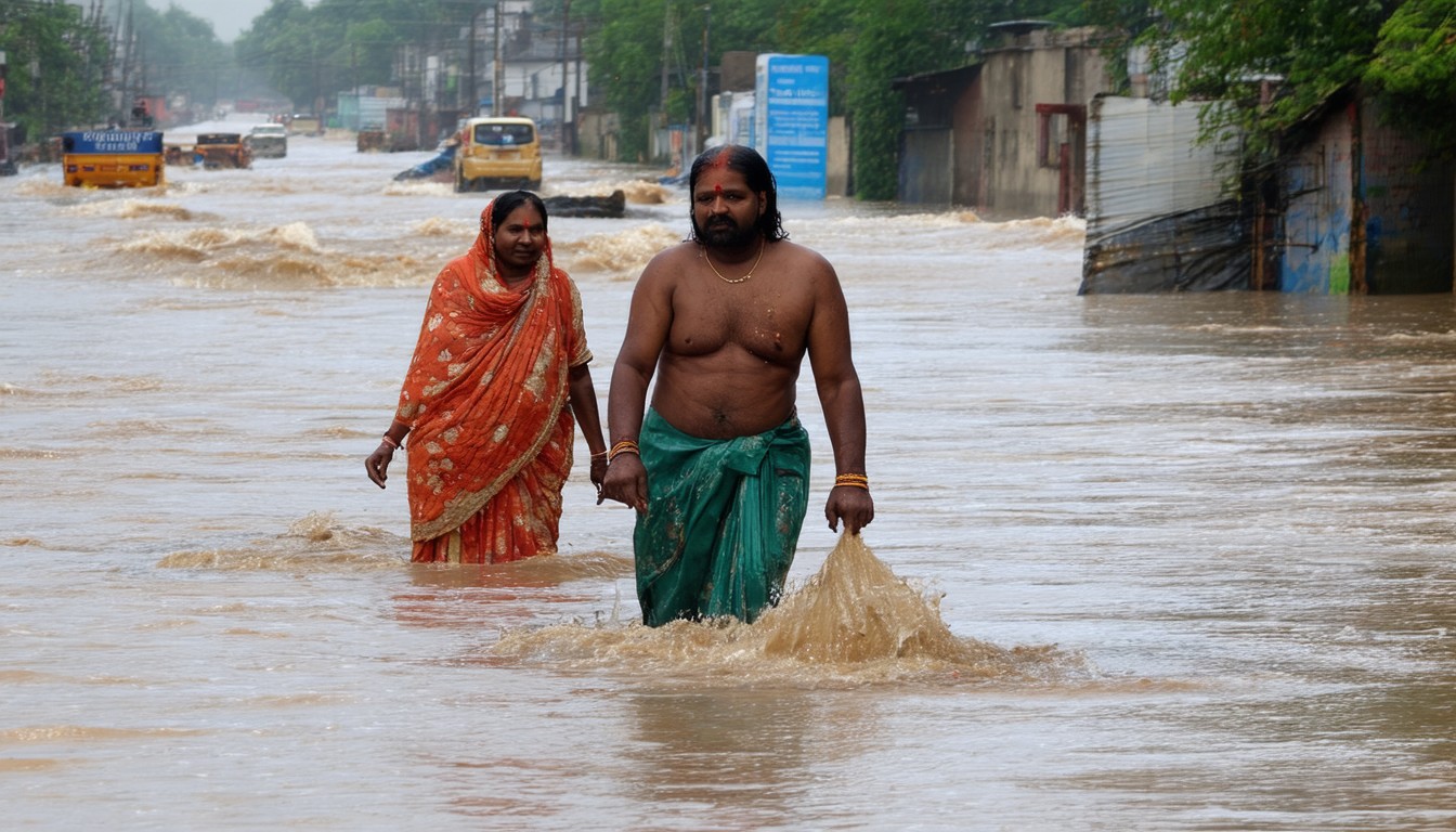
Current Updates: Impacted Areas and Response Efforts
Key Regions Affected by Recent Flooding
Recent weeks have seen water levels rise sharply along major stretches of the Ganges, particularly in the states of Uttar Pradesh, Bihar, and West Bengal. Several key locations—including Varanasi, Patna, and Farakka—have reported low-lying neighborhoods inundated due to excessive rainfall and upstream water release.
- Varanasi: Iconic ghats partially submerged, affecting religious tourism and local fishermen.
- Patna: Urban flooding disrupted railway and road movement, with authorities setting up temporary shelters.
- Farakka: Navigational challenges as river currents increased, threatening bridges and embankments.
Emergency Measures and Community Mobilization
Local authorities, backed by the National Disaster Response Force (NDRF) and state disaster management teams, have launched coordinated evacuation drives in high-risk zones. Relief efforts involve:
- Temporary shelters for displaced families
- Distribution of clean drinking water and food supplies
- Medical camps to prevent outbreaks of waterborne diseases
- Real-time monitoring using satellite and drone imagery
Despite these measures, logistical constraints in rural areas and the sheer scale of the population present ongoing challenges.
“Timely coordination between agencies has saved countless lives, but sustainable upstream planning is crucial for long-term resilience,” remarks Dr. Praveen Kumar, a disaster management expert specializing in riverine systems.
Root Causes: Climate, Infrastructure, and Human Factors
Monsoon Patterns and Glacial Melt
The South Asian monsoon typically arrives between June and September, bringing vital rainfall but also raising the risk of floods along major rivers like the Ganges. Variations in monsoon strength—believed to be linked to climate change—have led to more unpredictable and intense downpours. Additionally, increased glacial melt in the Himalayas augments water inflow during the early summer.
Changes in River Morphology and Land Use
Beyond climatic influences, human interventions have altered the river’s natural flow. Construction of embankments, barrages, and urban expansion into floodplains disrupts natural drainage and retention. Siltation—where sediment accumulates in riverbeds—reduces the capacity of the Ganges to carry floodwaters, worsening overflow events.
Agricultural Vulnerability and Societal Impact
Floods routinely damage standing crops, particularly rice and sugarcane, which are the backbone of local economies in the basin. Smallholder farmers often lack insurance, leaving them highly vulnerable to each year’s losses. Beyond immediate destruction, repeated inundation leads to long-term food insecurity and out-migration from rural communities.
Economic and Social Implications
Displacement and Health Concerns
Flood situations near the Ganges routinely displace hundreds of thousands, with marginalized groups bearing the brunt. Makeshift camps, though rapidly established, struggle with overcrowding and limited sanitation facilities, raising the risk of diseases such as cholera and dengue. Children, the elderly, and those with preexisting conditions are especially at risk.
Economic Disruption
Floods impact the regional economy in several ways:
- Agriculture: Crop losses, livestock deaths, and soil erosion increase farmers’ debt burdens.
- Infrastructure: Damaged roads, railways, and power lines stall broader economic activity.
- Education: Schools often double as relief camps, disrupting education for extended periods.
Analysts estimate that cumulative annual flood losses in the Ganges basin amount to billions of dollars, factoring in direct damages and lost productivity.
Government Strategies and Community-Based Adaptation
Short-Term Mitigation
In response to seasonal forecasts, authorities employ a blend of traditional and modern approaches:
- Strengthening river embankments before peak monsoon months
- Pre-positioning relief supplies in likely flood-prone areas
- Issuing timely public warnings through radio, SMS, and social platforms
Long-Term Planning for Resilience
Recognizing the limits of reactive strategies, several states have undertaken comprehensive floodplain mapping and are promoting climate-resilient agriculture (such as flood-tolerant rice varieties). Community-based organizations play a growing role, training local volunteers in first response and promoting alternative livelihoods that are less susceptible to flood damage.
A notable example has been the deployment of “flood-resilient schools” in Bihar—structures elevated above historic high-water marks, functioning both as schools and emergency shelters.
Inter-State and International Collaboration
Given the Ganges’ transboundary flow, integrated water management requires cooperation between Indian states and neighboring Bangladesh. Joint river commissions review upstream water releases, aiming to balance flood mitigation with irrigation and navigation needs downstream.
Looking Forward: Navigating Recovery and Future Risk
While annual flooding along the Ganges remains a complex reality, proactive adaptation can lessen its impact. Investments in real-time hydrological monitoring, resilient infrastructure, and inclusive development planning hold promise for reducing disaster risk. Ultimately, the interplay between climate trends, river management, and community adaptation will determine the region’s resilience as environmental realities continue to shift.
Summary and Recommendations
The flood situation near the Ganges showcases both the vulnerability of riverine communities and the opportunities for innovation in disaster response. Effective risk reduction must blend scientific forecasting, community engagement, and long-term investment in infrastructure. Policy coordination—both across sectors and borders—will be critical as climate variability continues to influence the river’s behavior.
FAQs
What causes frequent floods near the Ganges?
Floods near the Ganges are mainly caused by heavy monsoon rains, glacial melt from the Himalayas, reduced river capacity due to silt build-up, and altered land use practices that disrupt natural water flow.
How do floods affect local residents along the Ganges?
Frequent flooding leads to property damage, crop loss, displacement of families, and increased health risks due to poor sanitation and waterborne diseases. Livelihoods and access to basic services are often disrupted.
What measures are in place to manage the flood situation?
Authorities deploy disaster response teams, set up temporary shelters, distribute relief supplies, and use early warning systems to inform residents. Projects like stronger embankments, raised shelters, and better water management are ongoing.
Are flood events becoming more common or severe?
Many experts and government reports suggest that flood events have become more frequent and intense, likely due to changing monsoon patterns and climate change impacts, combined with growing population pressure.
How can affected communities adapt to future floods?
Communities adopt measures like elevated housing, flood-resilient crops, early warning systems, and participation in local first-response training. Collaboration with local NGOs and agencies is crucial for building long-term resilience.
What role does regional cooperation play in flood management?
Transboundary cooperation, especially between states and neighboring countries like Bangladesh, ensures better coordination on water release, disaster warning, and resource sharing to minimize flood impacts downstream.